West Virginia statistical areas
West Virginia statistical areas
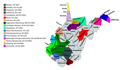
The U.S. State of West Virginia currently has 20 statistical areas that have been delineated by the Office of Management and Budget (OMB). On July 21, 2023, the OMB delineated five combined statistical areas, 10 metropolitan statistical areas, and five micropolitan statistical areas in West Virginia.[1]
Statistical areas
The Office of Management and Budget (OMB) has designated more than 1,000 statistical areas for the United States and Puerto Rico.[2] These statistical areas are important geographic delineations of population clusters used by the OMB, the United States Census Bureau, planning organizations, and federal, state, and local government entities.
The OMB defines a core-based statistical area (commonly referred to as a CBSA) as "a statistical geographic entity consisting of the county or counties (or county-equivalents) associated with at least one core[a] of at least 10,000 population, plus adjacent counties having a high degree of social and economic integration with the core as measured through commuting ties with the counties containing the core."[2] The OMB further divides core-based statistical areas into metropolitan statistical areas (MSAs) that have "a population of at least 50,000" and micropolitan statistical areas (μSAs) that have "a population of at least 10,000, but less than 50,000."[2]
The OMB defines a combined statistical area (CSA) as "a geographic entity consisting of two or more adjacent core-based statistical areas with employment interchange measures[b] of at least 15%."[2] The primary statistical areas (PSAs) include all combined statistical areas and any core-based statistical area that is not a constituent of a combined statistical area.
Table
The table below describes the 22 United States statistical areas and 55 counties of the State of West Virginia with the following information:[3]
- The combined statistical area (CSA) as designated by the OMB.[1]
- The CSA population according to 2019 US Census Bureau population estimates.[4]
- The core-based statistical area (CBSA)[2] as designated by the OMB.[1]
- The CBSA population according to 2019 US Census Bureau population estimates [4]
- The county name
- The county population according to 2019 US Census Bureau population estimates [4]
- The Metropolitan Division name, if applicable[1]
- The Metropolitan Division population according to 2019 US Census Bureau population estimates [4]
| Combined statistical area | 2020 population | Core-based statistical area | 2020 population | County | 2020 population | Metropolitan Division | 2020 population |
|---|---|---|---|---|---|---|---|
| Charleston-Huntington-Ashland, WV-OH-KY CSA | 660,768 401,377 | Charleston, WV MSA | 210,605 | Kanawha County, West Virginia | 180,745 | none | |
| Boone County, West Virginia | 21,809 | ||||||
| Clay County, West Virginia | 8,051 | ||||||
| Huntington-Ashland, WV-KY-OH MSA | 376,155 190,772 | Cabell County, West Virginia | 94,350 | ||||
| Lawrence County, Ohio | 58,240 | ||||||
| Putnam County, West Virginia | 57,440 | ||||||
| Boyd County, Kentucky | 48,261 | ||||||
| Wayne County, West Virginia | 38,982 | ||||||
| Greenup County, Kentucky | 35,962 | ||||||
| Carter County, Kentucky | 26,627 | ||||||
| Lawrence County, Kentucky | 16,293 | ||||||
| Portsmouth, OH μSA | 74,008 | Scioto County, Ohio | 74,008 | ||||
| Washington-Baltimore-Arlington, DC-MD-VA-WV-PA CSA | 10,030,543 219,933 | Hagerstown-Martinsburg, MD-WV MSA | 293,844 139,139 | Washington County, Maryland | 154,705 | ||
| Berkeley County, West Virginia | 122,076 | ||||||
| Morgan County, West Virginia | 17,063 | ||||||
| Washington-Arlington-Alexandria, DC-VA-MD-WV MSA | 6,278,542 57,701 | Fairfax County, Virginia | 1,150,309 | Arlington-Alexandria-Reston, VA-WV MD | 3,121,401 57,701 | ||
| Prince William County, Virginia | 482,204 | ||||||
| Loudoun County, Virginia | 420,959 | ||||||
| Arlington County, Virginia | 238,643 | ||||||
| City of Alexandria, Virginia | 159,467 | ||||||
| Stafford County, Virginia | 156,927 | ||||||
| Spotsylvania County, Virginia | 140,032 | ||||||
| Fauquier County, Virginia | 72,972 | ||||||
| Jefferson County, West Virginia | 57,701 | ||||||
| Culpeper County, Virginia | 52,552 | ||||||
| City of Manassas, Virginia | 42,772 | ||||||
| Warren County, Virginia | 40,727 | ||||||
| City of Fredericksburg, Virginia | 27,982 | ||||||
| City of Fairfax, Virginia | 24,146 | ||||||
| City of Manassas Park, Virginia | 17,219 | ||||||
| Clarke County, Virginia | 14,783 | ||||||
| City of Falls Church, Virginia | 14,658 | ||||||
| Rappahannock County, Virginia | 7,348 | ||||||
| Prince George's County, Maryland | 967,201 | Washington, DC-MD MD | 1,823,363 | ||||
| District of Columbia | 689,545 | ||||||
| Charles County, Maryland | 166,617 | ||||||
| Montgomery County, Maryland | 1,062,061 | Frederick-Gaithersburg-Bethesda, MD MD | 1,333,778 | ||||
| Frederick County, Maryland | 271,717 | ||||||
| Winchester, VA-WV MSA | 142,632 23,093 | Frederick County, Virginia | 91,419 | none | |||
| City of Winchester, Virginia | 28,120 | ||||||
| Hampshire County, West Virginia | 23,093 | ||||||
| Baltimore-Columbia-Towson, MD MSA | 2,846,722 | Baltimore County, Maryland | 854,535 | ||||
| Anne Arundel County, Maryland | 588,261 | ||||||
| Baltimore City, Maryland | 585,708 | ||||||
| Howard County, Maryland | 334,529 | ||||||
| Harford County, Maryland | 260,924 | ||||||
| Carroll County, Maryland | 172,891 | ||||||
| Queen Anne's County, Maryland | 49,874 | ||||||
| Lexington Park, MD MSA | 206,560 | St. Mary's County, Maryland | 113,777 | ||||
| Calvert County, Maryland | 92,783 | ||||||
| Chambersburg, PA MSA | 155,932 | Franklin County, Pennsylvania | 155,932 | ||||
| Easton, MD μSA | 37,526 | Talbot County, Maryland | 37,526 | ||||
| Lake of the Woods, VA μSA | 36,254 | Orange County, Virginia | 36,254 | ||||
| Cambridge, MD μSA | 32,531 | Dorchester County, Maryland | 32,531 | ||||
| Fairmont-Clarksburg, WV CSA | 146,639 | Clarksburg, WV μSA | 90,434 | Harrison County, West Virginia | 65,921 | ||
| Taylor County, West Virginia | 16,705 | ||||||
| Doddridge County, West Virginia | 7,808 | ||||||
| Fairmont, WV μSA | 56,205 | Marion County, West Virginia | 56,205 | ||||
| none | Morgantown, WV MSA | 140,038 | Monongalia County, West Virginia | 105,822 | |||
| Preston County, West Virginia | 34,216 | ||||||
| Beckley, WV MSA | 115,439 | Raleigh County, West Virginia | 74,951 | ||||
| Fayette County, West Virginia | 40,488 | ||||||
| Parkersburg-Marietta-Vienna, WV-OH CSA | 149,201 89,490 | Parkersburg-Vienna, WV MSA | 89,490 | Wood County, West Virginia | 84,296 | ||
| Wirt County, West Virginia | 5,194 | ||||||
| Marietta, OH μSA | 59,711 | Washington County, Ohio | 59,711 | ||||
| none | Wheeling, WV-OH MSA | 139,513 73,016 | Belmont County, Ohio | 66,497 | |||
| Ohio County, West Virginia | 42,425 | ||||||
| Marshall County, West Virginia | 30,591 | ||||||
| Bluefield, WV-VA μSA | 100,093 59,664 | Mercer County, West Virginia | 59,664 | ||||
| Tazewell County, Virginia | 40,429 | ||||||
| Pittsburgh-Weirton-Steubenville, PA-OH-WV CSA | 2,777,801 51,654 | Weirton-Steubenville, WV-OH MSA | 116,903 51,654 | Jefferson County, Ohio | 65,249 | ||
| Hancock County, West Virginia | 29,095 | ||||||
| Brooke County, West Virginia | 22,559 | ||||||
| Pittsburgh, PA MSA | 2,467,000 | Allegheny County, Pennsylvania | 1,250,578 | ||||
| Westmoreland County, Pennsylvania | 364,663 | ||||||
| Washington County, Pennsylvania | 209,349 | ||||||
| Butler County, Pennsylvania | 193,763 | ||||||
| Beaver County, Pennsylvania | 168,215 | ||||||
| Fayette County, Pennsylvania | 128,804 | ||||||
| Lawrence County, Pennsylvania | 86,070 | ||||||
| Armstrong County, Pennsylvania | 65,558 | ||||||
| Hermitage, PA μSA | 110,652 | Mercer County, Pennsylvania | 110,652 | ||||
| Indiana, PA μSA | 83,246 | Indiana County, Pennsylvania | 83,246 | ||||
| none | Elkins, WV μSA | 27,932 | Randolph County, West Virginia | 27,932 | |||
| Cumberland, MD-WV μSA | 95,044 26,938 | Allegany County, Maryland | 68,106 | ||||
| Mineral County, West Virginia | 26,938 | ||||||
| none | Greenbrier County, West Virginia | 32,977 | |||||
| Logan County, West Virginia | 32,567 | ||||||
| Jackson County, West Virginia | 27,791 | ||||||
| Mason County, West Virginia | 25,453 | ||||||
| Nicholas County, West Virginia | 24,604 | ||||||
| Upshur County, West Virginia | 23,816 | ||||||
| Mingo County, West Virginia | 23,568 | ||||||
| Wyoming County, West Virginia | 21,382 | ||||||
| Lincoln County, West Virginia | 20,463 | ||||||
| McDowell County, West Virginia | 19,111 | ||||||
| Lewis County, West Virginia | 17,033 | ||||||
| Barbour County, West Virginia | 15,465 | ||||||
| Wetzel County, West Virginia | 14,442 | ||||||
| Hardy County, West Virginia | 14,299 | ||||||
| Roane County, West Virginia | 14,028 | ||||||
| Braxton County, West Virginia | 12,447 | ||||||
| Monroe County, West Virginia | 12,376 | ||||||
| Summers County, West Virginia | 11,959 | ||||||
| Grant County, West Virginia | 10,976 | ||||||
| Ritchie County, West Virginia | 8,444 | ||||||
| Webster County, West Virginia | 8,378 | ||||||
| Tyler County, West Virginia | 8,313 | ||||||
| Pocahontas County, West Virginia | 7,869 | ||||||
| Pleasants County, West Virginia | 7,653 | ||||||
| Gilmer County, West Virginia | 7,408 | ||||||
| Tucker County, West Virginia | 6,762 | ||||||
| Calhoun County, West Virginia | 6,229 | ||||||
| Pendleton County, West Virginia | 6,143 | ||||||
| State of West Virginia | 1,793,716 | ||||||
See also
 Geography portal
 United States portal
 West Virginia portal


Notes
- ^ The OMB defines a core as "a densely settled concentration of population, comprising an Urban Area (of 10,000 or more population) delineated by the Census Bureau, around which a core-based statistical area is delineated."[2]
- ^ The OMB defines the employment interchange measure as "the sum of the percentage of workers living in the smaller entity who work in the larger entity plus the percentage of employment in the smaller entity that is accounted for by workers who reside in the larger entity."[2]
References
- ^ a b c d e Revised Delineations of Metropolitan Statistical Areas, Micropolitan Statistical Areas, and Combined Statistical Areas, and Guidance on Uses of the Delineations of These Areas (July 21, 2023). "OMB BULLETIN NO. 23-01" (PDF). Office of Management and Budget. Retrieved November 5, 2023.
{{cite web}}: CS1 maint: multiple names: authors list (link) - ^ a b c d e f g "2020 Standards for Delineating Core Based Statistical Areas". Office of Management and Budget. July 16, 2021. Retrieved December 15, 2021.
- ^ An out-of-state area and its population are displayed in green. An area that extends into more than one state is displayed in teal. A teal population number over a black population number show the total population versus the in-state population.
- ^ a b c d "Annual Estimates of the Resident Population for Counties in the United States: April 1, 2010 to July 1, 2019". United States Census Bureau, Population Division. April 2020. Retrieved April 9, 2020.
External links
West Virginia at Wikipedia's sister projects
 Media from Commons
 News from Wikinews
 Quotations from Wikiquote
 Travel information from Wikivoyage
- Office of Management and Budget
- United States Census Bureau
- v
- t
- e
Charleston (capital)
- Abortion
- Culture
- Climate change
- Crime
- Demographics
- Economy
- Education
- Gun laws
- LGBT rights
- Mass media
- Allegheny Mountains
- Allegheny Plateau
- Blue Ridge Mountains
- Charleston metropolitan area
- Cumberland Mountains
- Cumberland Plateau
- Eastern Panhandle
- Huntington metropolitan area
- North Central
- Ohio Valley
- Northern Panhandle
- Potomac Highlands
- Ridge-and-Valley Appalachians
- Shenandoah Valley
- Southern
- Washington–Baltimore metropolitan area
- Barbour
- Berkeley
- Boone
- Braxton
- Brooke
- Cabell
- Calhoun
- Clay
- Doddridge
- Fayette
- Gilmer
- Grant
- Greenbrier
- Hampshire
- Hancock
- Hardy
- Harrison
- Jackson
- Jefferson
- Kanawha
- Lewis
- Lincoln
- Logan
- Marion
- Marshall
- Mason
- McDowell
- Mercer
- Mineral
- Mingo
- Monongalia
- Monroe
- Morgan
- Nicholas
- Ohio
- Pendleton
- Pleasants
- Pocahontas
- Preston
- Putnam
- Raleigh
- Randolph
- Ritchie
- Roane
- Summers
- Taylor
- Tucker
- Tyler
- Upshur
- Wayne
- Webster
- Wetzel
- Wirt
- Wood
- Wyoming
 West Virginia portal
38°38′27″N 80°37′22″W / 38.6409°N 80.6227°W / 38.6409; -80.6227 (State of West Virginia)


