Tertenia
Comune in Sardinia, Italy
Tertenia Dardania | |
|---|---|
Comune | |
| Comune di Tertenia | |
 | |
 Coat of arms | |
Location of Tertenia  | |
39°42′N 9°35′E / 39.700°N 9.583°E / 39.700; 9.583 | |
| Country | Italy |
| Region | Sardinia |
| Province | Province of Nuoro (NU) |
| Government | |
| • Mayor | Giulio Murgia |
| Area | |
| • Total | 117.77 km2 (45.47 sq mi) |
| Elevation | 129 m (423 ft) |
| Population (31 December 2015)[1] | |
| • Total | 3,888 |
| • Density | 33/km2 (86/sq mi) |
| Demonym | Terteniesi |
| Time zone | UTC+1 (CET) |
| • Summer (DST) | UTC+2 (CEST) |
| Postal code | 08047 |
| Dialing code | 0782 |
| Patron saint | St. Sophia |
| Saint day | September 1 |
Tertenia is a comune (municipality) in the Province of Nuoro in the Italian region Sardinia, located about 70 kilometres (43 mi) northeast of Cagliari and about 25 kilometres (16 mi) south of Tortolì.
Tertenia borders the following municipalities: Cardedu, Gairo, Jerzu, Lanusei, Loceri, Osini, Ulassai.
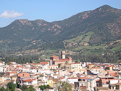
It is located in a high valley at the base of Mt. Arbu and Mt. Ferru, along the Rio Quirra river.[2]
References
Wikimedia Commons has media related to Tertenia.
- v
- t
- e
- Aritzo
- Arzana
- Atzara
- Austis
- Bari Sardo
- Baunei
- Belvì
- Birori
- Bitti
- Bolotana
- Borore
- Bortigali
- Cardedu
- Desulo
- Dorgali
- Dualchi
- Elini
- Fonni
- Gadoni
- Gairo
- Galtellì
- Gavoi
- Girasole
- Ilbono
- Irgoli
- Jerzu
- Lanusei
- Lei
- Loceri
- Loculi
- Lodè
- Lodine
- Lotzorai
- Lula
- Macomer
- Mamoiada
- Meana Sardo
- Noragugume
- Nuoro
- Oliena
- Ollolai
- Olzai
- Onanì
- Onifai
- Oniferi
- Orani
- Orgosolo
- Orosei
- Orotelli
- Ortueri
- Orune
- Osidda
- Osini
- Ottana
- Ovodda
- Perdasdefogu
- Posada
- Sarule
- Silanus
- Sindia
- Siniscola
- Sorgono
- Talana
- Tertenia
- Teti
- Tiana
- Tonara
- Torpè
- Tortolì
- Triei
- Ulassai
- Urzulei
- Ussassai
- Villagrande Strisaili
Authority control databases | |
|---|---|
| International |
|
| National |
|
 | This Sardinia location article is a stub. You can help Wikipedia by expanding it. |
- v
- t
- e


