Siksa, Chorbat
Village in nothern Pakistan
Village in Gilgit Baltistan, Pakistan
Siksa سکسا | |
|---|---|
Village | |
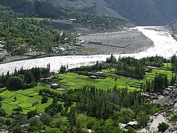 Shyok River passing Siksa | |
| 34°55′48″N 76°36′57″E / 34.93000°N 76.61583°E / 34.93000; 76.61583 | |
| Country | Pakistan |
| Autonomous territory |  Gilgit Baltistan Gilgit Baltistan |
| District | Ghanche |
| Subdivision | Chorbat |
| Time zone | UTC+5 (PST) |
| • Summer (DST) | UTC+6 (GMT+5) |
| Website | https://swa.org.pk |
Siksa is a village in the sub division Chorbat Valley, Ghanche District of Gilgit-Baltistan, lying 150 kilometres (93 mi) east of Skardu, near the border of Pakistan and India at an elevation of 2,725 metres (8,940 ft).
In historical travel writings Siksa is referred to as the "Chorbat village". It is also described as the principal village of the Chorbat ilaqa, where the officials of Chorbat lived.[1] Siksa is at the end of the Chorbat Lungpa valley, which leads to the Chorbat La pass, the historical route between Baltistan and Ladakh.[2]
The language spoken is Balti. The entire population is Muslim of the Sofia Noorbakhshia and Ahl-i-Hadith or Ahl-e-Hadith (Urdu: اہلِ حدیث, people of hadith) sects.
Etymology
The name "Siksa" is believed to be derived from the Balti word meaning "a land with shortage of water". For hundred of years this village has struggled for access to water for agriculture. Different community projects were started to meet the need for water. One of the major projects was initiated in early 19th century to construct a channel from its eastern border which resulted in the fulfilment of agricultural needs.
Geography
Sika has an average elevation of about 8,950 feet (2,730 m), and is situated along the banks of the Shyok River, a tributary of the Indus. Villages near Siksa includes Kalan, Sogmos, Chuar and Siari.[1]
Resources
The natural resources of the village include agriculture, horticultural resources, the Shyok River, mountains and peaks. The agriculture in the village is only summer based due to extreme cold in the winter where temperature goes to -10 C. The crops include some beans, maize, potatoes, and other food crops however communities have experimented less with the agriculture due to the natural limiting factors i.e. extreme cold.
Transport
Siksa is accessible only by the road, The normal route to Siksa is via Shyok Valley Road, that connect it to the District Headquarters Khaplu and to Skardu. The climate can have adverse effects on transport in and out of the Siksa, as the roads in and out of can be blocked for weeks.
References
- ^ a b Gazetteer of Kashmir and Ladak (1890), p. 750.
- ^ Drew, The Jummoo and Kashmir Territories (1875): "The Chorbat Pass is the boundary of Baltistan in this direction; by this road also used to come Balti raiders, as the remains of a fort at Yogma Hanū prove, which the people of the valley had put up against them."
- Sources
- Gazetteer of Kashmir and Ladak, 1890
- Bhattacharji, Romesh (2012), Ladakh: Changing, Yet Unchanged, New Delhi: Rupa Publications – via Academia.edu
- Drew, Frederic (1875), The Jummoo and Kashmir Territories: A Geographical Account, E. Stanford – via archive.org
- Enriquez, Colin Metcalfe (1915), The Realm of the Gods: A Tale of Travel in Kangra, Mandi, Kulu, Chamba, Kishtwar, Kashmir, Ladakh and Baltistan, Thacker, Spink – via archive.org
Further reading
- Siksa Valley: Turning Gilgit-Baltistan's barren lands into green miracles, 17 September 2018
- FEATURE-In Pakistan, a high mountain water pipe brings a bonus: peace
- Shridhar Kaul (1992). Ladakh through the Ages, towards a New Identity. Indus Publishing. ISBN 81-85182-75-2.
- Sarina Singh; Lindsay Brown; Paul Clammer; Rodney Cocks; John Mock; Kimberley O'Neil (2008). Pakistan & the Karakoram Highway. Lonely Planet. pp. 292–293. ISBN 978-1-74104-542-0.
- Raja Iftikhar. The History of Baltistan.
- Iftikhar Ali Raja Zahid. Waadi-E-Chorbat.
- v
- t
- e
places
- Balghar
- Barah Valley
- Chorbat Valley
- Ghawari
- Gulshan-e-Kabir
- Haldi
- Hassanabad
- Hushe
- Keris Valley
- Khaney
- Khaplu (district capital)
- Kharfaq
- Kharkoo
- Kondus
- Kunais Valley
- Siksa
- Thagas
- Thalay
- Yugo
- Kuroo


