Pioneer Race Course

Pioneer Race Course, also known as the Pioneer Race Track,[1] was a horse race track opened in March 1851, in the southern Mission District of San Francisco, California.[2]
Pioneer was the first race course in San Francisco.[3] At the time that it was built, no streets existed in the neighborhood. After construction, it appears to have been bounded by 24th St. (formerly Park St.), 26th St. (formerly Navy St.), Capp St., and Florida St.[4]
It was funded and built by local businessmen George Treat and his brother John Treat.[5] The racetrack was physically built by Alfred Green.[6]
The race course was sold to the San Francisco Homestead Association in 1862 (or 1863) for $500 per acre, but would be worth $20,000 per acre within a decade.[7] Lots within the property were auctioned in 1864. Early houses built within the property are now part of the Shotwell Street historic district,[8] and another house within the property may be the oldest remaining home building in San Francisco.[9]
Historical events
On May 21, 1854, the Pioneer Race Course was the site of a duel between lawyer George T. Hunt and his friend Numa Hubert, an ex-member of the California state assembly. On the third round, Hunt was shot in the abdomen and died.[10][11][12]
In October 1854, the race course was the site of the stock show at the first California State Fair.[13]
From 1862 until 1863 (some sources report 1865), the site of the course served a civil war encampment called Camp Alert for the 2nd California Cavalry, before they moved to Salt Lake City, Utah.[14]
The course was the site of a celebration of the completion of the San Francisco-San Jose Railway in October 1863, and for a time also served as the railway's San Francisco station.[15] The positioning of the course, as well as the later built nearby Union Race Course, appear to have affected the placement of the railway's extension into the city, and therefore still affects local property lines.[16]
Maps
-
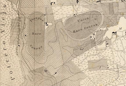 1857 Map showing Pioneer Race Course and nearby Union Race Course (West at top of map)
 -
 1864 San Francisco surveyor showing Pioneer Race Course Tract (housing tract made from the Course's land) (East at top of map)
 -
 1861 Map of San Francisco, showing Pioneer Race Course (North at top of map)


References
- ^ "San Francisco Directory". SFGenealogy.org. 1863. Retrieved 2022-04-20.
- ^ Williams, Amy. "The Del Mar Race Track 75 Years of Turf and Surf" (PDF). San Diego History. Retrieved October 12, 2014.
- ^ Sharpsteen, William Crittenden. "Vanished Waters of Southeastern San Francisco". The Virtual Museum of the City of San Francisco. Retrieved 12 October 2014.
- ^ Lockwood, Charles. "The Mission Becomes a Resort, 1850s". FoundSF. Retrieved 12 October 2014.
- ^ "When the Mission District was home to horse racing". San Francisco Chronicle. Retrieved 2017-08-26.
- ^ "SAN FRANCISCO CITY PLANNING COMMISSION RESOLUTION NO. 13559" (PDF). City of San Francisco. August 19, 1993. Retrieved October 4, 2014.
- ^ Lockwood, Charles. "Real Estate Speculation Starts". FoundSF. Retrieved October 12, 2014.
- ^ "South Mission Historic Resources Survey Historic District Description- Shotwell Street Victoriana" (PDF). San Francisco Planning Department. Retrieved 2 March 2014.
- ^ "Treat Treatise". Burrito Justice. October 15, 2010. Retrieved October 12, 2014.
- ^ Chiang, Yee (November 1, 1964). Silent Traveller in San Francisco. W. W. Norton & Company. pp. 366. ISBN 978-0393084221.
- ^ "SFgenealogy Obituaries and Death Notices". Retrieved 2022-04-20.
- ^ "The Hubert-Hunt Duel on One Voter Project". May 20, 2012. Retrieved October 12, 2014.
- ^ Appendix to the Journals of the Forty-Third Session of the Legislature of the State of California. Vol. 5. California. 1919. p. 365.
- ^ "Camp Alert". The California State Military Museum. Archived from the original on 2011-06-13.
- ^ Kneiss, Gilbert (1954). Bonanza Railroads. Stanford University Press. pp. 37–39. ISBN 9780804724135.
- ^ "Mission History as Revealed By Creeks, Streams, Lakes and Lagoons on Burrito Justice". Retrieved September 14, 2013.
37°45′5″N 122°24′58″W / 37.75139°N 122.41611°W / 37.75139; -122.41611
- v
- t
- e
City and County of San Francisco
- City Hall
- Mayor
- Board of Supervisors
- Superior Court
- San Francisco consulates
- Sister cities
- Arts Commission
- Board of Education
- City Attorney
- District Attorney
- Ethics Commission
- Fire Department
- Human Rights Commission
- San Francisco International Airport
- Municipal Transportation Agency
- Police Commission
- Police Department
- Port of San Francisco
- Public Library
- Public Utilities Commission
- Public Works
- Recreation & Parks Department
- Sheriff's Department
- Transportation Authority
- San Francisco Unified School District
- Youth Commission
- Alamo Square
- Balboa Park
- Buena Vista Park
- Candlestick Point
- Corona Heights Park
- Dolores Park
- Glen Canyon Park
- Golden Gate National Recreation Area
- Golden Gate Park
- Grand View Park
- Lafayette Park
- Lake Merced
- Lincoln Park
- McLaren Park
- Mountain Lake Park
- Panhandle
- Pine Lake Park
- Pioneer Park/Coit Tower
- The Presidio
- San Francisco Maritime
- Stern Grove
- South Park
- Sutro Heights Park
- Washington Square Park
- Yerba Buena Gardens
- Topics
- Category
- Portal


