Mizhrichchia
Village in Crimea
Mizhrichchia Міжріччя | |
|---|---|
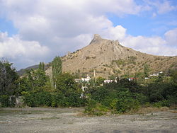 View of Mizhrichchia with the Crimean Mountains in the background. | |
| 44°52′43″N 34°50′55″E / 44.87861°N 34.84861°E / 44.87861; 34.84861 | |
| Republic | Crimea |
| Raion | Feodosia Raion |
| First mentioned | 1381 |
| Area | |
| • Total | 0.6 km2 (0.2 sq mi) |
| Elevation | 198 m (650 ft) |
| Population (2014) | |
| • Total | 519 |
| • Density | 870/km2 (2,200/sq mi) |
| Time zone | UTC+4 (MSK) |
| Postal code | 98030 |
| Area code | +380 6566 |
| Website | http://rada.gov.ua/ |
Mizhrichchia or Mezhdurechye (Ukrainian: Міжріччя; Russian: Междуречье; literally, between the rivers) is a village in the Feodosia Raion of Crimea, a territory recognized by a majority of countries as part of Ukraine and annexed by Russia as the Republic of Crimea.[2]
Mizhrichchia is located on Crimea's southern shore in the Crimean Mountains at an elevation of 198 m (650 ft).[1] Its population was 510 in the 2001 Ukrainian census.[2] Current population: 519 (2014 Census).[3]
History
Previously, the settlement was known as the Ai-Serez village (Crimean Tatar: Ay Serez). Following the forced deportation of the Crimean Tatars in 1944, the Presidium of the Supreme Soviet of the Russian SFSR published a decree on May 18, 1948 renaming the settlement along with many others throughout Crimea from their native Crimean Tatar names to their current variants.[4]
In 1886, the village of Ai-Serez was located in the Taraktash Volost of the Feodosia Povit of the Taurida Governorate. At that time, the settlement had a population of 655 inhabitants; it had two mosques located in its settlement.[5] In the 1897 Russian Empire census, the population increased to 1,464 inhabitants, 1,458 of which belonged to the Muslim faith.[6]
People from Mizhrichchia
- Mustafa Dzhemilev, former Chairman of the Mejlis of the Crimean Tatar People, People's Deputy of Ukraine since 1998
- Abdurakhman Chubarov, father of Refat Chubarov, current Chairman of the Mejlis of the Crimean Tatar People[7]
References
- ^ a b "Mizhrichchia (Crimea region)". weather.in.ua. Retrieved 7 January 2014.
- ^ a b "Mizhrichchia, Autonomous Republic of Crimea, City of Sudak". Regions of Ukraine and their Structure (in Ukrainian). Verkhovna Rada of Ukraine. Archived from the original on 4 March 2016. Retrieved 7 January 2014.
- ^ Russian Federal State Statistics Service (2014). "Таблица 1.3. Численность населения Крымского федерального округа, городских округов, муниципальных районов, городских и сельских поселений" [Table 1.3. Population of Crimean Federal District, Its Urban Okrugs, Municipal Districts, Urban and Rural Settlements]. Федеральное статистическое наблюдение «Перепись населения в Крымском федеральном округе». ("Population Census in Crimean Federal District" Federal Statistical Examination) (in Russian). Federal State Statistics Service. Retrieved 4 January 2016.
- ^ Presidium of the Supreme Soviet of the Russian SFSR from 18.05.1948 about the renaming of populated settlements in the Crimean Oblast (Указ Президиума ВС РСФСР от 18.05.1948 о переименовании населённых пунктов Крымской области) on the Russian Wikisource.
- ^ Волости и важнѣйшія селенія Европейской Россіи. По данным обслѣдованія, произведеннаго статистическими учрежденіями Министерства Внутренних Дѣл, по порученію Статистическаго Совѣта. Изданіе Центральнаго Статистическаго Комитета. Выпуск VIII. Губерніи Новороссійской группы. СанктПетербургъ. 1886. — VI + 157 с.
- ^ Населенныя мѣста Россійской Имперіи в 500 и болѣе жителей съ указаніем всего наличнаго въ них населенія и числа жителей преобладающихъ вѣроисповѣданій по даннымъ первой всеобщей переписи 1897 г. С-Петербург. 1905. — IX + 270 + 120 с., (стор. 1-216)
- ^ "The Chairman of the Crimean Tatar's Mejlis father died". Ukrainian Independent Information Agency (in Ukrainian). 31 March 2014. Retrieved 8 January 2015.
External links
 Media related to Mizhrichchia at Wikimedia Commons
- v
- t
- e
 | This article about a location in Crimea is a stub. You can help Wikipedia by expanding it. |
- v
- t
- e


