Maxvorstadt
Borough of Munich
You can help expand this article with text translated from the corresponding article in German. (November 2011) Click [show] for important translation instructions.
- View a machine-translated version of the German article.
- Machine translation, like DeepL or Google Translate, is a useful starting point for translations, but translators must revise errors as necessary and confirm that the translation is accurate, rather than simply copy-pasting machine-translated text into the English Wikipedia.
- Do not translate text that appears unreliable or low-quality. If possible, verify the text with references provided in the foreign-language article.
- You must provide copyright attribution in the edit summary accompanying your translation by providing an interlanguage link to the source of your translation. A model attribution edit summary is
Content in this edit is translated from the existing German Wikipedia article at [[:de:Maxvorstadt]]; see its history for attribution. - You may also add the template
{{Translated|de|Maxvorstadt}}to the talk page. - For more guidance, see Wikipedia:Translation.
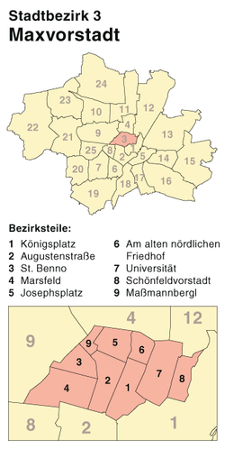
Maxvorstadt (Central Bavarian: Maxvorstod) is a central borough of Munich, Bavaria, Germany and forms the Stadtbezirk (borough) 3 Maxvorstadt. Since 1992, this borough comprises the former boroughs 5, 6 and 7 (Maxvorstadt-Universität, Maxvorstadt-Königsplatz-Marsfeld and Maxvorstadt-Josephsplatz).
Location
The borough is next to the north-western part of the Old City. The Englischer Garten is the Eastern border, Schwabing is in the North, Neuhausen-Nymphenburg in the North-West. The borough Schwanthalerhöhe is its south-western neighbor and Ludwigsvorstadt-Isarvorstadt is in the south. The Eastern parts of Maxvorstadt are often mistakenly attributed to the borough of Schwabing.
Traffic
The Maxvorstadt is drafted as a quadratical grid and is shaped by the north-south axes Schleißheimer Straße and Ludwigstraße; the parallel streets Amalienstraße, Türkenstraße, Barer Straße, Schraudolphstraße, Arcisstraße, Luisenstraße and Augustenstraße run between them. These two main streets are linked by the east-west connections Gabelsbergerstraße, Theresienstraße, Heßstraße, Schellingstraße, Zieblandstraße, Görresstraße and Georgenstraße, Theresienstraße and Gabelsbergerstraße are one-way streets.
The Maxvorstadt is accessible by public transport by the underground line U2 and the stations Königsplatz, Theresienstraße and Josephsplatz, the underground lines U3 and U6 and the station Universität and also the underground line U1 and the station Stiglmaierplatz. Additionally, the tram lines 16, 17, 20, 21, 27 and 28 as well as several bus lines are running here.
Notable landmarks

- 8. November 1939 (Denkmal)
- Abtei St. Bonifaz (Munich)
- Akademie der Bildenden Künste München
- Akademiegalerie
- Alter Botanischer Garten (Munich)
- Alter Nordfriedhof (Munich)
- Altstadtring
- Altstadtringtunnel
- Amerikanisches Generalkonsulat in München
- Architekturmuseum der Technischen Universität München
- Arnold & Richter Cine Technik
- Augenklinik Herzog Carl Theodor
- Bahnhof München Hackerbrücke
- Bayerische Staatskanzlei
- Bayerisches Kriegsministerium
- Bennosäule
- Bernheimer-Haus
- Braunes Haus
- Bundestagswahlkreis München-Nord
- Dachauer Straße
- Delphinbrunnen (Munich)
- Denkmal für Franz Xaver Gabelsberger (Munich)
- Dichtergarten (Munich)
- Die Neue Sammlung
- Königliche Erzgießerei in München
- Führerbau
- Gabriel Filmtheater
- Geologisches Museum München
- Glaspalast (Munich)
- Hackerbrücke
- Harmlos
- Hochschule für Musik und Theater München
- Hochschule für Philosophie München
- Hochschule für Politik München
- Hofbrunnwerkkanal
- Hofgartenkaserne
- Institut français (Munich)
- Justizpalast (Munich)
- Kaim-Saal
- Karstadt München Bahnhofplatz
- Kleines Spiel
- Königliche Kunstgewerbeschule München
- Königsplatz (Munich)
- Circus Krone
- Kronebau
- Kunstsammlung des Herzoglichen Georgianums
- Landeskirchenamt München
- Lenbachplatz
- Löwenbräukeller
- Maillingerstraße
- Marsfeld (Munich)
- Max-Planck-Institut für Sozialrecht und Sozialpolitik
- Münchner Haus der Kulturinstitute
- Münchner Theater für Kinder
- Museum für Abgüsse Klassischer Bildwerke
- Neptunbrunnen (Munich)
- Nornenbrunnen (Munich)
- NS-Dokumentationszentrum
- Odeon (Munich)
- Odeonsplatz
- Erich Ott
- Prinz-Carl-Palais
- Propyläen (Munich)
- Richard-Wagner-Straße (Munich)
- Rundfunkplatz
- Salzstadelkaserne
- Schauspiel München
- Schelling-Salon
- Schleißheimer Straße (Munich)
- Siegestor
- SiemensForum München
- Simpl (Munich)
- SportA
- Sprachen & Dolmetscher Institut München
- St. Benno (Munich)
- St. Joseph (Munich)
- St. Markus (Munich)
- St.-Benno-Viertel
- Staatliche Antikensammlungen
- Staatsarchiv München
- Städtische Galerie im Lenbachhaus
- Städtisches Luisengymnasium München
- Stimmkreis München-Schwabing
- The Charles Hotel
- Theater Die Kleine Freiheit
- TheaterRaum München
- Türkengraben
- Türkenkaserne
- U-Bahnhof Josephsplatz
- U-Bahnhof Königsplatz
- U-Bahnhof Stiglmaierplatz
- U-Bahnhof Theresienstraße
- Winzererstraße
- Wittelsbacher-Gymnasium München
- Wittelsbacherbrunnen (Lenbachplatz)
- Wohnhaus Reinemann
- Wohnheimsiedlung Maßmannplatz
- Zentraler Omnibusbahnhof München
See also
Wikimedia Commons has media related to Maxvorstadt.
Wikivoyage has a travel guide for Munich/Maxvorstadt.
48°09′00″N 11°34′10″E / 48.15000°N 11.56944°E / 48.15000; 11.56944
- v
- t
- e
- Allach-Untermenzing
- Altstadt-Lehel
- Aubing-Lochhausen-Langwied
- Au-Haidhausen
- Berg am Laim
- Bogenhausen
- Feldmoching-Hasenbergl
- Hadern
- Laim
- Ludwigsvorstadt-Isarvorstadt
- Maxvorstadt
- Milbertshofen-Am Hart
- Moosach
- Neuhausen-Nymphenburg
- Obergiesing
- Pasing-Obermenzing
- Ramersdorf-Perlach
- Schwabing-Freimann
- Schwabing-West
- Schwanthalerhöhe
- Sendling
- Sendling-Westpark
- Thalkirchen-Obersendling-Forstenried-Fürstenried-Solln
- Trudering-Riem
- Untergiesing-Harlaching


