List of National Natural Landmarks in Montana
Map all coordinates using OpenStreetMap
Download coordinates as:
- KML
- GPX (all coordinates)
- GPX (primary coordinates)
- GPX (secondary coordinates)
The following is a list of National Natural Landmarks in Montana. There are 10 in total.


Hell Creek Fossil Area
Glacial Lake Missoula
Middle Fork Canyon
Bug Creek Fossil Area
Capitol Rock
Square Butte
class=notpageimage|
Montana National Natural Landmarks (clickable map)| Name | Image | Date | Location | County | Ownership | Description | |
|---|---|---|---|---|---|---|---|
| 1 | Bridger Fossil Area | 1973 | Carbon | federal (Bureau of Land Management) | Contains fossils of Deinonychus antirrhopus. | ||
| 2 | Bug Creek Fossil Area | 1966 | 47°40′59″N 106°13′09″W / 47.68299°N 106.219193°W / 47.68299; -106.219193 (Bug Creek Fossil Area) | McCone | federal (Charles M. Russell National Wildlife Refuge) | Produced abundant remains of small, Cretaceous mammals. | |
| 3 | Capitol Rock | 1976 | 45°35′45″N 104°07′12″W / 45.59584°N 104.120134°W / 45.59584; -104.120134 (Capitol Rock) | Carter | federal (Custer National Forest) | A remnant of the once continuous blanket of Tertiary deposits that covered much of the Great Plains. | |
| 4 | Cloverly Formation Site | 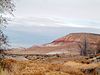 | 1973 | Big Horn | tribal land (Crow Nation) | Contains early Cretaceous vertebrate fossils. | |
| 5 | Glacial Lake Missoula |  | 1966 | 46°56′20″N 114°08′37″W / 46.938889°N 114.143611°W / 46.938889; -114.143611 (Lake Missoula) | Sanders | private | Contains the best examples of giant flood ripples in the North American continent. |
| 6 | Hell Creek Fossil Area | 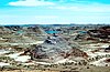 | 1966 | 46°09′N 107°29′W / 46.15°N 107.48°W / 46.15; -107.48 (Hell Creek Fossil Area) | Several | mixed- state, private | The type locality for Tyrannosaurus rex, Ankylosaurus magniventris, and Brachychampsa fontana fossils. |
| 7 | Medicine Lake Site | 1980 | 48°28′05″N 104°22′54″W / 48.468056°N 104.381667°W / 48.468056; -104.381667 (Medicine Lake National Wildlife Refuge) | Sheridan | federal (Medicine Lake National Wildlife Refuge) | An exceptional example of the processes of continental glaciation, including till, outwash, eskers, kames, and terrace deposits. | |
| 8 | Middle Fork Canyon | 1977 | 46°07′54″N 111°06′35″W / 46.131701°N 111.109849°W / 46.131701; -111.109849 (Middle Fork Canyon) | Gallatin | federal (Bureau of Land Management) | An outstanding example of a canyon cut across the grain of the geologic structure by a superposed stream. | |
| 9 | Red Rock Lakes National Wildlife Refuge | 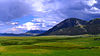 | 1966 | 44°37′49″N 111°46′53″W / 44.630278°N 111.781389°W / 44.630278; -111.781389 (Red Rock Lakes National Wildlife Refuge) | Beaverhead | federal | A series of relatively undisturbed, high-altitude ecosystem types representative of pre-European settlement conditions. |
| 10 | Square Butte (mountain) | 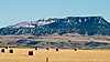 | 1980 | 47°28′35″N 110°14′31″W / 47.476499°N 110.241999°W / 47.476499; -110.241999 (Square Butte (mountain)) | Chouteau | federal (Bureau of Land Management) | One of the best examples of banded magmatic rock in the United States. |
See also
- v
- t
- e
National Natural Landmarks in the United States
- Alabama
- Alaska
- Arizona
- Arkansas
- California
- Colorado
- Connecticut
- Delaware
- Florida
- Georgia
- Hawaii
- Idaho
- Illinois
- Indiana
- Iowa
- Kansas
- Kentucky
- Louisiana
- Maine
- Maryland
- Massachusetts
- Michigan
- Minnesota
- Mississippi
- Missouri
- Montana
- Nebraska
- Nevada
- New Hampshire
- New Jersey
- New Mexico
- New York
- North Carolina
- North Dakota
- Ohio
- Oklahoma
- Oregon
- Pennsylvania
- Rhode Island
- South Carolina
- South Dakota
- Tennessee
- Texas
- Utah
- Vermont
- Virginia
- Washington
- West Virginia
- Wisconsin
- Wyoming


