List of National Historic Landmarks in West Virginia


Old Main (Bethany College)
Campbell Mansion
Campbell Mansion
Wheeling Suspension Bridge
West Virginia Independence Hall
West Virginia Independence Hall

Grave Creek Mound
Weston Hospital Main Building
Traveller's Rest
Alexander Wade House
Matewan Historic District
The Greenbrier
Reber Radio Telescope
class=notpageimage|
West Virginia National Historic Landmarks (clickable map)This article includes a List of National Historic Landmarks in West Virginia.
National Historic Landmarks in West Virginia
There are 17 National Historic Landmarks in the state. The following is a complete list.
Map all coordinates using OpenStreetMap
Download coordinates as:
- KML
- GPX (all coordinates)
- GPX (primary coordinates)
- GPX (secondary coordinates)
| [1] | Landmark name | Image | Date designated[2] | Location | County | Description |
|---|---|---|---|---|---|---|
| 1 | Andrews Methodist Episcopal Church | 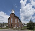 | October 5, 1992 (#70000667) | Grafton 39°20′20″N 80°01′07″W / 39.3388548502°N 80.0185436005°W / 39.3388548502; -80.0185436005 (Andrews Methodist Episcopal Church) | Taylor | Where the Mother's Day holiday was started. |
| 2 | Baltimore and Ohio Railroad Martinsburg Shops |  | July 31, 2003 (#03001045) | Martinsburg 39°27′39″N 77°57′34″W / 39.460833°N 77.959444°W / 39.460833; -77.959444 (Baltimore and Ohio Railroad Martinsburg Shops) | Berkeley | Architecturally significant railway buildings, also where the Great Railroad Strike of 1877 began. |
| 3 | Campbell Mansion | 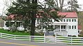 | April 19, 1994 (#70000651) | Bethany 40°12′21″N 80°32′51″W / 40.2057321567°N 80.5476076794°W / 40.2057321567; -80.5476076794 (Campbell Mansion) | Brooke | Home of Alexander Campbell, founder and president of Bethany College |
| 4 | Clover site |  | April 27, 1992 (#92001881) | Lesage 38°35′24″N 82°13′54″W / 38.590000°N 82.231667°W / 38.590000; -82.231667 (Clover site) | Cabell | Archaeological site. |
| 5 | Davis and Elkins Historic District |  | June 7, 1998 (#96001129) | Elkins 38°55′44″N 79°50′57″W / 38.9289808836°N 79.8492664145°W / 38.9289808836; -79.8492664145 (Davis and Elkins Historic District) | Randolph | Historic district including Graceland and Halliehurst mansions |
| 6 | Elkins Coal and Coke Company Historic District |  | May 4, 1983 (#83003249) | Bretz 39°32′42″N 79°48′35″W / 39.545000°N 79.809722°W / 39.545000; -79.809722 (Elkins Coal and Coke Company Historic District) | Preston | 140 beehive coke ovens, the last operated in the United States. |
| 7 | Grave Creek Mound |  | July 19, 1964 (#66000751) | Moundsville 39°55′00″N 80°44′42″W / 39.91676°N 80.744978°W / 39.91676; -80.744978 (Grave Creek Mound) | Marshall | The United States' largest cone-shaped burial mound, 62 feet (19 m) tall, 240 feet (73 m) diameter at base. |
| 8 | The Greenbrier |  | June 21, 1990 (#74002000) | White Sulphur Springs 37°47′07″N 80°18′30″W / 37.7854°N 80.3083°W / 37.7854; -80.3083 (The Greenbrier) | Greenbrier | Hotel and emergency relocation center for the U.S. congress. |
| 9 | Jefferson County Courthouse |  | December 11, 2023 (#100009833) | Charles Town 39°17′21″N 77°51′37″W / 39.2892°N 77.8603°W / 39.2892; -77.8603 (Jefferson County Courthouse) | Jefferson | |
| 10 | Matewan Historic District |  | February 18, 1997 (#93000303) | Matewan 37°37′23″N 82°09′59″W / 37.623056°N 82.166389°W / 37.623056; -82.166389 (Matewan Historic District) | Mingo | Site of bloody 1920 coal miners' strike depicted in John Sayles' film Matewan |
| 11 | Old Main, Bethany College |  | June 21, 1990 (#70000652) | Bethany 40°12′14″N 80°33′37″W / 40.2038891197°N 80.5603100305°W / 40.2038891197; -80.5603100305 (Old Main, Bethany College) | Brooke | Historic main building on Bethany College campus. |
| 12 | Reber Radio Telescope | 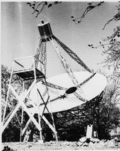 | December 20, 1989 (#72001291) | Green Bank 38°25′42″N 79°49′04″W / 38.428307822°N 79.8179043296°W / 38.428307822; -79.8179043296 (Reber Radio Telescope) | Pocahontas | First parabolic radio telescope, built by amateur astronomer Grote Reber. |
| 13 | Traveller's Rest |  | November 28, 1972 (#72001288) | Kearneysville 39°23′17″N 77°54′03″W / 39.388056°N 77.900833°W / 39.388056; -77.900833 (Traveller's Rest) | Jefferson | Homestead of General Horatio Gates and a rare surviving example of Virginia architect John Ariss's work. |
| 14 | Alexander Wade House |  | December 21, 1965 (#66000752) | Morgantown 39°37′31″N 79°57′30″W / 39.625271°N 79.958328°W / 39.625271; -79.958328 (Alexander Wade House) | Monongalia | Home of innovative educator Alexander Wade. |
| 15 | West Virginia Independence Hall |  | June 20, 1988 (#70000660) | Wheeling 40°03′53″N 80°43′20″W / 40.064742°N 80.722142°W / 40.064742; -80.722142 (West Virginia Independence Hall) | Ohio | Site of 1861–1863 pro-Union government of Virginia. |
| 16 | Weston Hospital | 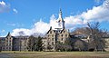 | June 21, 1990 (#78002805) | Weston 39°02′19″N 80°28′17″W / 39.03861°N 80.4713889°W / 39.03861; -80.4713889 (Weston Hospital) | Lewis | One of the largest hand-cut stone masonry buildings in the United States. |
| 17 | Wheeling Suspension Bridge | 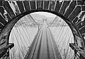 | May 15, 1975 (#70000662) | Wheeling 40°04′06″N 80°43′38″W / 40.0682684288°N 80.7273516865°W / 40.0682684288; -80.7273516865 (Wheeling Suspension Bridge) | Ohio | World's first long suspension bridge. |
See also
- National Register of Historic Places listings in West Virginia
- List of National Historic Landmarks by state
- List of National Natural Landmarks in West Virginia
References
- ^ Numbers represent an alphabetical ordering by significant words. Various colorings, defined here, differentiate National Historic Landmarks and historic districts from other NRHP buildings, structures, sites or objects.
- ^ The eight-digit number below each date is the number assigned to each location in the National Register Information System database, which can be viewed by clicking the number.
External links
- "National Historic Landmarks Survey: List of National Historic Landmarks by State--West Virginia (16)" (PDF). National Park Service. Retrieved November 14, 2007.
- National Historic Landmarks Program, at National Park Service
Map all coordinates using OpenStreetMap
Download coordinates as:
- KML
- GPX (all coordinates)
- GPX (primary coordinates)
- GPX (secondary coordinates)
- v
- t
- e
- Alabama
- Alaska
- Arizona
- Arkansas
- California
- Colorado
- Connecticut
- Delaware
- Florida
- Georgia
- Hawaii
- Idaho
- Illinois
- Indiana
- Iowa
- Kansas
- Kentucky
- Louisiana
- Maine
- Maryland
- Massachusetts
- Michigan
- Minnesota
- Mississippi
- Missouri
- Montana
- Nebraska
- Nevada
- New Hampshire
- New Jersey
- New Mexico
- New York
- North Carolina
- North Dakota
- Ohio
- Oklahoma
- Oregon
- Pennsylvania
- Rhode Island
- South Carolina
- South Dakota
- Tennessee
- Texas
- Utah
- Vermont
- Virginia
- Washington
- West Virginia
- Wisconsin
- Wyoming
| Insular area | |
|---|---|
| Associated state | |
| Foreign country |
| |
|---|---|
| Topics | |
| Lists by state |
|
| Lists by insular areas | |
| Lists by associated state | |
| Other areas | |
| Related | |
| |


