Komagome Station
Railway and metro station in Tokyo, Japan
 JR East
 Tokyo Metro
- JY Yamanote Line (JY-10)
- N Namboku Line (N-14)
- 1 island platform (JR East)
- 1 island platform (Tokyo Metro)
 Bus terminal
| Preceding station | Following station | |||
|---|---|---|---|---|
| Sugamo JY11 Next counter-clockwise | Yamanote Line | Tabata JY09 Next clockwise | ||
| Preceding station | Following station | |||
| Hon-komagome N13 towards Meguro | Namboku Line | Nishigahara N15 towards Akabane-iwabuchi | ||
Location | |
|---|---|
  Komagome Station Location within Special wards of Tokyo Show map of Special wards of Tokyo Komagome Station Komagome Station (Tokyo Bay and Bōsō Peninsula) Show map of Tokyo Bay and Bōsō Peninsula Komagome Station Komagome Station (Tokyo) Show map of Tokyo Komagome Station Komagome Station (Japan) Show map of Japan |
Komagome Station (駒込駅, Komagome-eki) is a railway station in Toshima, Tokyo, Japan, operated by the East Japan Railway Company (JR East) and the Tokyo subway operator Tokyo Metro.
Lines
Komagome Station is served by the circular Yamanote Line and by the Tokyo Metro Namboku Line subway line.
Station layout
JR East Platforms
The JR East section of the station is composed of one island platform serving two tracks.
Chest-height platform edge doors were installed on the Yamanote Line platforms during fiscal 2013.[1]
| 1 | JY Yamanote Line | for Tabata, Ueno, and Tokyo |
| 2 | for Ikebukuro, Shinjuku, and Shibuya |
-
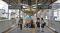 JR East platforms in 2019

Tokyo Metro Platforms
The Tokyo Metro section of the station is composed of one island platform serving two tracks.
| 1 | N Namboku Line | for Akabane-iwabuchi SR Saitama Rapid Railway Line for Urawa-misono |
| 2 |
|

-
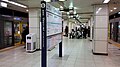 Tokyo Metro platforms in 2017

History
- 15 November 1910: This station was opened by Japanese Government Railways as a station of the Yamanote Line.
- 13 April 1945: The station building was burned down by an air raid during World War II.
- 1 April 1987: The Namboku Line station was opened by TRTA (now Tokyo Metro).
- 1 April 1987: The station facilities of the Yamanote Line were inherited by JR East after the privatization of the Japanese National Railways.
- 1 April 2004: The station facilities of the Namboku Line were inherited by Tokyo Metro after the privatization of the TRTA.[2]
- 2016: Station numbering was introduced to the Yamanote Line with Komagome being assigned station number JY10.[3][4]
Surrounding area
Rikugien Garden can be accessed by walking from this station.
Kyu-Furukawa Gardens can also be accessed by walking from this station.
See also
 Tokyo portal

References
- ^ グループ経営構想V [Group Business Vision V] (PDF) (in Japanese). Japan: East Japan Railway Company. 30 October 2012. p. 10. Archived from the original (PDF) on 2 December 2012. Retrieved 8 November 2012.
- ^ "「営団地下鉄」から「東京メトロ」へ" [From "Teito Rapid Transit Authority" to "Tokyo Metro"]. Tokyo Metro Online. 8 July 2006. Archived from the original on 16 May 2012. Retrieved 29 May 2022.
- ^ "⾸都圏エリアへ 「駅ナンバリング」を導⼊します" [Introduce “station numbering” to the Tokyo metropolitan area] (PDF). jreast.co.jp (in Japanese). 6 April 2016. Archived from the original (PDF) on 7 December 2022. Retrieved 7 January 2023.
- ^ Kusamachi, Yoshikazu (7 April 2016). "JA・JK・JT・AKB…JR東日本、首都圏で駅ナンバリングなど導入へ" [JA, JK, JT, AKB … JR East to introduce station numbering in the Tokyo metropolitan area]. Response Automotive Media (in Japanese). Archived from the original on 6 August 2022. Retrieved 7 January 2023.
External links
Wikimedia Commons has media related to Komagome Station.
- JR East station information (in Japanese)
- Tokyo Metro station information (in Japanese)
- v
- t
- e
Stations of the Yamanote Line
- Shinagawa
- Ōsaki
- Gotanda
- Meguro
- Ebisu
- Shibuya
- Harajuku
- Yoyogi
- Shinjuku
- Shin-Ōkubo
- Takadanobaba
- Mejiro
- Ikebukuro
- Ōtsuka
- Sugamo
- Komagome
- Tabata
- Nishi-Nippori
- Nippori
- Uguisudani
- Ueno
- Okachimachi
- Akihabara
- Kanda
- Tokyo
- Yūrakuchō
- Shimbashi
- Hamamatsuchō
- Tamachi
- Takanawa Gateway
- Shinagawa
JY
| ||||||||||
|---|---|---|---|---|---|---|---|---|---|---|
| Districts |
|  | ||||||||
| Major stations | ||||||||||
| Education | ||||||||||
| Landmarks | ||||||||||
35°44′11″N 139°44′49″E / 35.736289°N 139.746995°E / 35.736289; 139.746995


