Koip Peak
Mountain in the American state of California


Koip Peak
Location in California
Show map of California
Koip Peak
Koip Peak (the United States)
Show map of the United StatesKoip Peak is a 12,968-foot-elevation (3,953 meter) summit in Mono County, California, in the United States.[3] It is located in the Ansel Adams Wilderness, on land managed by Inyo National Forest. It is approximately 0.25 miles (0.40 km) outside of Yosemite National Park's eastern boundary, and 1.0 mile (1.6 km) west of Parker Peak.
Koip is derived from a Western Numic name meaning "mountain sheep".[5] Bighorn sheep roam in the area.[6]
Climate
According to the Köppen climate classification system, Koip Peak is located in an alpine climate zone.[7] Most weather fronts originate in the Pacific Ocean, and travel east toward the Sierra Nevada mountains. As fronts approach, they are forced upward by the peaks (orographic lift), causing them to drop their moisture in the form of rain or snowfall onto the range.
Gallery
-
 Koip Peak to the right of center
 -
 Snow-covered Koip Peak centered in back, flanked by Parker Peak (left) and Mount Lewis (right)
 -
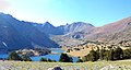
 View from Koip Peak: Alger Lakes, Blacktop Peak, and distant Ritter Range
 -
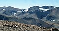 North aspects of Parker Peak (left), Koip Peak (right of center), and Kuna Peak (right) as seen from Mount Gibbs.


References
- ^ a b "Koip Peak, California". Peakbagger.com. Retrieved 2014-12-03.
- ^ "Sierra Peaks Section List" (PDF). Angeles Chapter, Sierra Club. Retrieved 2014-12-03.
- ^ a b "Koip Peak". Geographic Names Information System. United States Geological Survey, United States Department of the Interior. Retrieved 2021-11-22.
- ^ a b Secor, R.J. (2009). The High Sierra Peaks, Passes, and Trails (3rd ed.). Seattle: The Mountaineers. p. 397. ISBN 978-0898869712.
- ^ Bright, William (1998). 1500 California Place Names: Their Origin and Meaning. University of California Press. p. 78. ISBN 978-0-520-21271-8.
- ^ Browning, Peter (2011). Sierra Nevada Place Names: From Abbot to Zumwalt. Great West Books. p. 139. ISBN 978-0-944220-23-8.
- ^ "Climate of the Sierra Nevada". Encyclopædia Britannica.
External links
- "Koip Peak". SummitPost.org.
- v
- t
- e


