Canarsie Pol
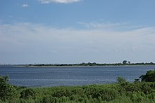
Canarsie Pol is an uninhabited island south of Canarsie, Brooklyn in Jamaica Bay, New York City. It is part of Gateway National Recreation Area.[1] Canarsie Pol is an irregular oval of about 300 acres (120 ha) (17,050,000 square feet (1,584,000 m2)). On 1910 maps, the island was originally much smaller; however, when nearby waterways were dredged to expand them for improved navigation, the sand and soil were piled on Canarsie Pol.[2] Near the island are other islands and marshes in the bay. Canarsie Pol has an elevation of 10 feet (3.0 m), and is a popular destination for kayakers embarking from the Canarsie Pier.[3][4]
References
- ^ Other Jamaica Bay Islands Archived September 28, 2011, at the Wayback Machine Retrieved August 15, 2011.
- ^ wikimapia.org Satellite view of Canarsie Pol and mainland Canarsie Retrieved August 15, 2011.
- ^ Visitor Programs and Events—Jamaica Bay Unit Retrieved August 15, 2011.
- ^ Canarsie Pier Retrieved August 15, 2011.
- v
- t
- e
- Long
- Manhattan
- Staten

- The Blauzes
- Chimney Sweeps
- City
- Cuban Ledge
- Green Flats
- Hart
- High
- Hunter
- Rat
- Twin
| Entirely in NJ | |
|---|---|
- Barren
- Bergen
- Broad Channel
- Coney
- Canarsie Pol
- Mau Mau
- Mill
- Plumb
- Ruffle Bar
- Berrien's
- Cob Dock
- Mill Rock
- Mussel
- North and South Brother
- Randalls and Wards
- Rikers
- Roosevelt
- U Thant (Belmont)
Former islands shown in italics
40°37′15″N 73°52′18″W / 40.62083°N 73.87167°W / 40.62083; -73.87167
 | This article about a location in Brooklyn, New York is a stub. You can help Wikipedia by expanding it. |
- v
- t
- e


