Bobonaro Municipality
You can help expand this article with text translated from the corresponding article in German. (July 2011) Click [show] for important translation instructions.
- View a machine-translated version of the German article.
- Machine translation, like DeepL or Google Translate, is a useful starting point for translations, but translators must revise errors as necessary and confirm that the translation is accurate, rather than simply copy-pasting machine-translated text into the English Wikipedia.
- Do not translate text that appears unreliable or low-quality. If possible, verify the text with references provided in the foreign-language article.
- You must provide copyright attribution in the edit summary accompanying your translation by providing an interlanguage link to the source of your translation. A model attribution edit summary is
Content in this edit is translated from the existing German Wikipedia article at [[:de:Bobonaro (Gemeinde)]]; see its history for attribution. - You may also add the template
{{Translated|de|Bobonaro (Gemeinde)}}to the talk page. - For more guidance, see Wikipedia:Translation.
Municipality of East Timor
Municipality of East Timor
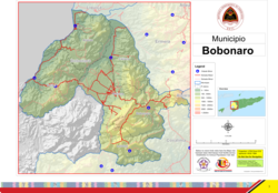
Official map

medium · 8th
Bobonaro (Portuguese: Município Bobonaro, Tetum: Munisípiu Bobonaru, or Munisípiu Buburnaru) is a municipality (and was formerly a district) in the Democratic Republic of Timor-Leste commonly known as East Timor. It is the second-most western municipality on the east half of the island. It has a population of 92,045 (Census 2010) and an area of 1,376 km2.
Etymology
The word Bobonaro is said to be a Portuguese approximation of the Tetum language word Buburnaru, which means 'tall eucalypt'.[2] However, there are also other explanations for the origin of the municipality's name.
Ho (transl. 'blood') and nalu, the name of a traditional woven basket also called a 'bote' or a 'taan', are words in the local Bunak language. The basket is worn on the back with a strap on the forehead. In combination, ho and nalu mean 'basket of blood' or 'basket of life', and Bobonaro approximates the combination.[3]
Additionally, the combination of the words bobo (transl. 'hide') and naru (transl. 'long') in another local language, Kemak, refer to a safe place where one can hide for a long time.[3]
Geography
The Savu Sea lies to the north of Bobonaro. The municipality borders the municipalities of Liquiçá to the northeast, Ermera to the east, Ainaro to the southeast, and Cova-Lima to the south. To the west lies the Indonesian province Nusa Tenggara Timur. In Portuguese Timor, the then district had the same boundaries as the present municipality; however its capital was at Vila Armindo Monteiro, which is now called Bobonaro.[4]
The capital of Bobonaro is East Timor's fourth largest city, Maliana. As of 2004[update] it had a population of 13,200.[5] It sits at 9.00°S and 125.22°E, 149 km from to the southwest of the national capital, Dili. The next two largest cities in the municipality are Bobonaro City (also known as Aubá), with 6,700 people; and Lolotoi with a population of 3,800. Another village is Atabae in Atabae Administrative Post.
 |  |
Administrative posts
The municipality's administrative posts (formerly sub-districts) are:[6]
The administrative posts are divided into 50 sucos ("villages") in total.
Infrastructure
The main road between Dili and the Indonesian border at Batugade runs through this municipality, clinging closely to the coast for almost its entire length through the municipality. It runs through Atabae and Balibó administrative posts.
Border crossings
The main border crossing between East Timor and Indonesia is located in this district at Batugade where the East Timor Immigration Post is located. The Indonesian checkpoint is located in Mota'ain in Belu Regency, Nusa Tenggara Timur Province. Another minor border crossing checkpoint is maintained by the Immigration Service of East Timor within this municipality at Tunibibi near Maliana. The Indonesian post for this crossing is at Turiskain, also in Belu Regency.
History
The municipality had been a popular destination in Timor, due to its mountains and hot springs, but it suffered much violence in the war for independence. Balibó, located about 10 miles from the Indonesian border, was estimated by Human Rights Watch to be 70% destroyed during the militia violence that preceded the referendum for East Timorese independence. It was also the site of the killing of five Australian-based journalists (the Balibo Five) by Indonesian forces on 16 October 1975 during an incursion by Indonesia into what was then Portuguese Timor.
Demographics
In addition to the official languages of Tetum and Portuguese, a large part of Bobonaro speaks the Malayo-Polynesian languages Bekais and Kemak and Papuan language Bunak, which are designated "national languages" by the constitution.
See also
References
Notes
- ^ "Sub-national HDI - Area Database - Global Data Lab". hdi.globaldatalab.org. Retrieved 13 September 2018.
- ^ Hull, Geoffrey (June 2006). "The placenames of East Timor" (PDF). Placenames Australia: Newsletter of the Australian National Placenames Survey: 6–7. Archived from the original (PDF) on 14 February 2017. Retrieved 4 June 2018.
- ^ a b "Perfil: 2. Toponímia" [Profile: 2. Toponymy]. Bobonaro Municipality (in Tetum). Retrieved 18 July 2022.
- ^ Brajendra Kumar (2006). Encyclopaedia of Southeast Asia (set of 5 Vols.). Akansha Publishing House. ISBN 81-837-0073-X.
- ^ "East Timor: Country Woman's Association" (PDF). University of New England. February 2012. Archived from the original (PDF) on 22 February 2017. Retrieved 22 February 2017.
- ^ Gunn, Geoffrey C (2011). Historical Dictionary of East Timor. Lanham, Maryland: Scarecrow Press. pp. 51–52. ISBN 9780810867543.
Bibliography
- Soares, Rosália E M (2017). Tais Husi Bobonaro, Timor-Leste / Os Têxteis de Bobonaro, Timor-Leste / The Textiles of Bobonaro, Timor-Leste (in Tetum, Portuguese, and English). Dili: Governo de Timor-Leste. Retrieved 4 May 2023.
- Bobonaro District Profile (PDF) (Report). April 2002. Archived from the original (PDF) on 28 March 2009. Retrieved 27 February 2022.
- Munisipio Bobonaro: Planu Estartejiku Desenvolvimentu Munisipal [Bobonaro Municipality: Municipal Strategic Development Plan] (Report) (in Tetum). Ministry of State Administration (East Timor) / Administration of Bobonaro Municipality. 2015. Retrieved 18 July 2022.
- Perfil Distritu Bobonaro [Bobonaro District Profile] (PDF) (Report) (in Tetum). 2012. Archived (PDF) from the original on 3 March 2014. Retrieved 18 July 2022.
External links
![]() Media related to Bobonaro (Municipality) at Wikimedia Commons
Media related to Bobonaro (Municipality) at Wikimedia Commons
- Bobonaro Municipality – official site (in Tetum with some content in English)
- Bobonaro Municipality – information page on Ministry of State Administration site (in Portuguese and Tetum)
Portals:
 Asia
Asia Geography


- v
- t
- e

Authority control databases | |
|---|---|
| International |
|
| National |
|


